Atif Aninda Rahman

MS in Geographic Information Science, University of Denver Urban Networks, Accessibility & GeoAI

Prospective PhD student in Geography / GIScience (Fall 2027).
I study urban accessibility, mobility equity, and GeoAI. My research combines GIS, remote sensing, spatial statistics, and machine learning to understand how cities function and how better geospatial data can support more equitable planning.

About

Atif Aninda Rahman

I'm an MS student in Geographic Information Science in the Department of Geography and the Environment at the University of Denver. My masters capstone builds a urban accessiblity model for the Denver Aurora Lakewood region to measure whether people can really reach groceries and transit within 15 minutes, then uses spatial statistics like Moran's I, hot spot analysis, and GWR to see which regions are inaccessible and why. I found that about 1.5 million people have no walkable access to groceries, mostly in the outer suburbs.

Alongside my studies, I work as a Graduate Teaching Assistant, leading weekly labs of about 25 students in ArcGIS Pro, ArcPy and Cartographic Map outputs. Before Denver, I spent two and a half years as a Research Consultant in Energy & Infrastructure Geospatial Analytics at the Center for Environmental and Geographic Information Services (CEGIS) in Dhaka. There I oversaw physical surveys, including route surveys, bathymetric surveys, and drone surveys, for an onshore gas pipeline feasibility study, then processed that data using GIS and Python for environmental and social impact assessments.

I hold a Bachelor of Urban and Regional Planning from Khulna University of Engineering & Technology (KUET), where my thesis identified suitable locations for green infrastructure using a multi criteria suitability analysis. I've also co-authored two peer reviewed journal articles, one on ecosystem services in urban Khulna and one on Bangladesh's COVID 19 crisis response, leading the core analysis on both.

I'm now exploring PhD programs in Geography and GIScience. I want to use GeoAI to build better infrastructure data in the neighborhoods where official maps fall short, so accessibility research can be fairer, not just more accurate.

CurrentlyMS in GIS (exp. June 2027) · Graduate Teaching Assistant, University of Denver
Core toolsOSMnx · NetworkX · ArcPy · ArcGIS Pro · QGIS · GeoPandas · GDAL
Research MethodsUrban Network Analysis · Moran's I · GWR · Machine Learning · Remote Sensing
ProgrammingPython (NumPy, Pandas, Shapely) · SQL · PySAL
ML / Deep LearningTensorFlow · Keras · CNN (ResNet50)
Research

Research
interests

My research investigates how cities can become more equitable by improving the quality of geospatial data used to measure accessibility. I combine GIS, spatial statistics, remote sensing, and GeoAI to study whether residents truly have walkable access to essential services and why accessibility disparities emerge across neighborhoods.

My master's research revealed that approximately 1.5 million residents in the Denver–Aurora–Lakewood metropolitan region lack walkable grocery access. During this work, I realized that many underserved neighborhoods also suffer from incomplete infrastructure data, limiting the reliability of accessibility models themselves.

Finally, I want to develop GeoAI methods that automatically improve sidewalk and infrastructure mapping in data-poor environments and integrate these improved datasets into accessibility models that better support equitable urban planning.

Read Full Research Statement ↓

Future Research Vision

My long-term goal is to build intelligent geospatial systems that continuously improve accessibility data as cities evolve. By combining GeoAI, remote sensing, and spatial statistics, I hope to develop methods that allow planners to identify emerging inequities before they become permanent features of the urban landscape.

  • Accessibility & mobility equity (spatial justice)

    My main focus. I measure whether people actually have fair, walkable access to daily needs: groceries, transit, parks, schools using network analysis and spatial statistics, and where that access breaks down along income lines.

  • GeoAI & deep learning for geospatial data

    Using GeoAI to fill in and correct the map and infrastructure data that accessibility models depend on, especially in places where that data is incomplete. Also includes CNN-based image classification more broadly.

  • Remote sensing for land use & environmental monitoring

    Using satellite and drone imagery to track land cover, urban growth, and site suitability. This is the applied side of my geospatial work.

  • Reproducible geospatial data engineering

    A recurring thread across my projects is building pipelines, not one-off maps: relational geodatabase design (ER diagrams, topology, subtypes), GDAL/OGR raster-vector workflows, and parallelized batch processing of multi-tile DEM data that mirrors HPC job-array patterns.

Projects

Research and Projects

JAN 2026

15-Minute City Accessibility Tool

Custom ArcPy geoprocessing tool in ArcGIS Pro that quantifies and ranks neighborhood-level accessibility to essential services: schools, parks, food retail, transit, healthcare across Denver Metro, using weighted dual scoring of service density and spatial proximity over a reproducible, configurable pipeline. This tool did the scoring using euclidian distance and is extended further to the full capstone study on the right, which extends it with urban street network and spatial statistical analysis

ArcPy · ArcGIS Pro · Geoprocessing tool

View on GitHub ↗

MAY 2026

Measuring 15-Minute City Accessibility in Denver Urban Areas: A Spatial Statistical Analysis

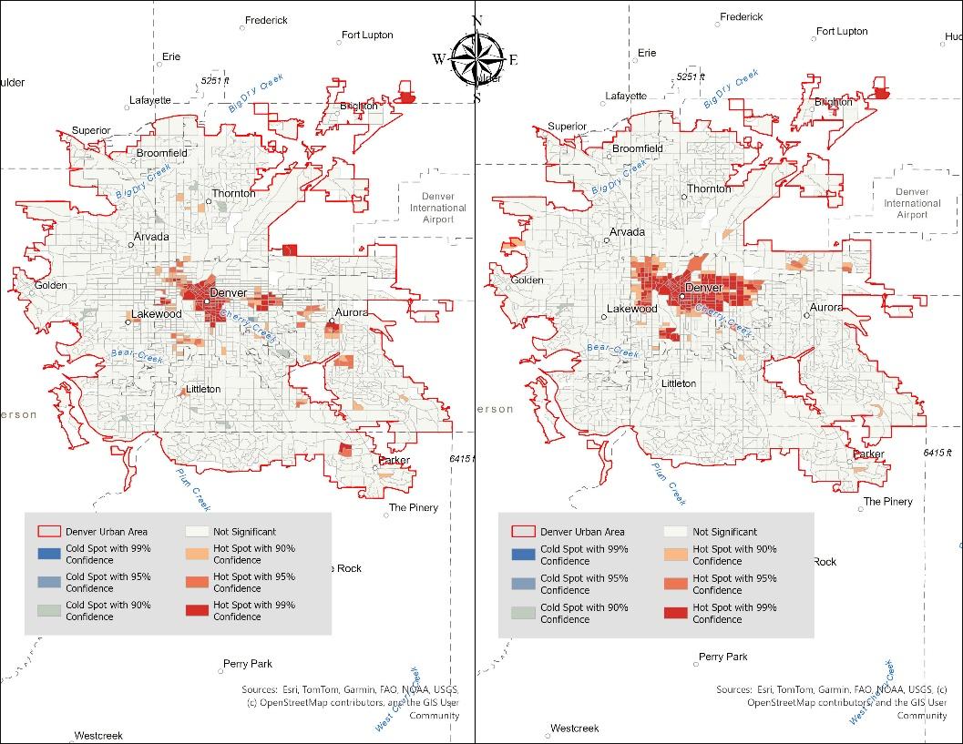
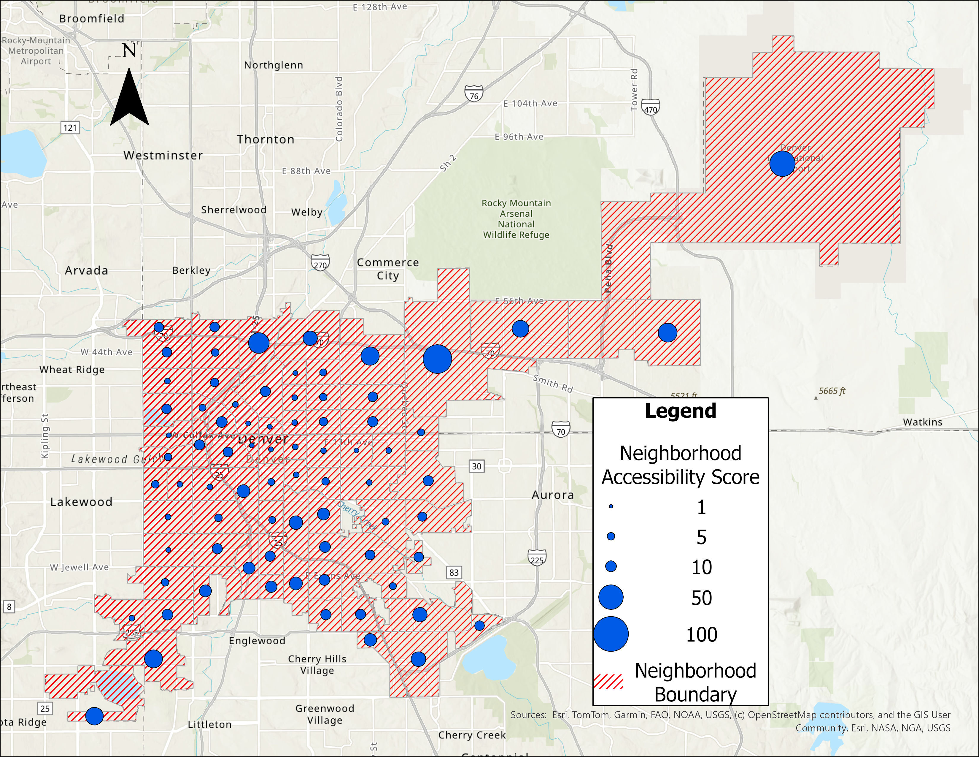
My Capstone research builds on this project that I did for my Geographic Information Analysis course. Here, I developed a slope-adjusted pedestrian network model to measure grocery and transit accessibility across the Denver-Aurora-Lakewood region, then testing for spatial relation between urban amenities and demographic indicators using Global & Local Moran's I, Getis-Ord Gi* hot spot analysis, and Geographically Weighted Regression. Found that roughly 1.5 million residents lack walkable grocery access, concentrated in outer suburbs, while access clusters tightly around the urban core.

ArcGIS Pro · Moran's I · GWR · Hot Spot Analysis · Rasterio

Read the full report (PDF) ↓

JUNE 2026

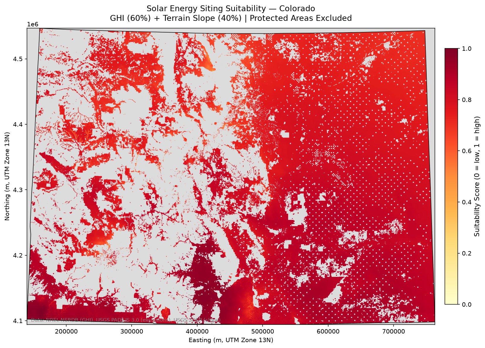
Solar Siting Suitability: Colorado

Multi-criteria suitability model for solar energy siting across Colorado, combining SolarGIS irradiance data with USGS protected-area constraints in an open-source geospatial Python workflow.

Python · SolarGIS · USGS Protected Areas

View on GitHub ↗

JAN 2024

Deep Learning Classifier Model: COVID-19 Chest X-Rays

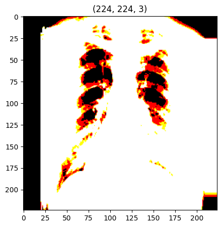
ResNet50 convolutional neural network trained on 21,165 chest X-ray images to classify COVID-19 presence, built as an end-to-end reproducible ML pipeline in TensorFlow/Keras. Mentored by Dr. Chang Zhao, University of Florida reached ~80% classification accuracy.

21,000+ IMAGES ·TensorFlow · Keras · CNN / ResNet50

View on GitHub ↗

MAR 2023

Onshore Gas Pipeline Feasibility & Environmental Impact Assessment

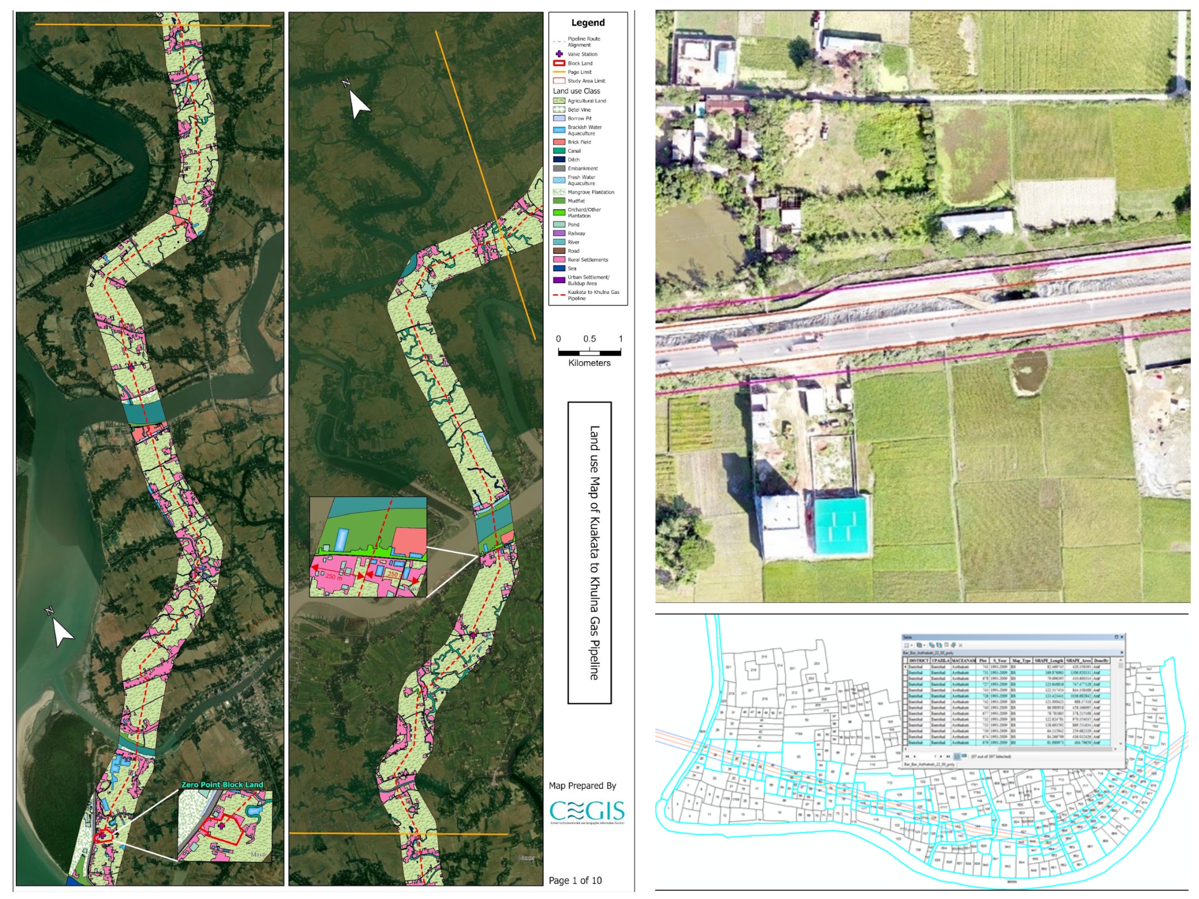
Oversaw physical surveys for a multi-phase feasibility and environmental study of a proposed onshore gas pipeline: detailed route surveys using RTK and total station across the full Barishal segment, hydrological/bathymetric surveys of river crossings along the route, and drone surveys for real-time land-use imagery. In the office, I used GIS to build interactive maps and landuse layers from satellite and multispectral imagery for the Environmental and Social Impact Assessment, and wrote Python scripts to calculate pipeline route angle points, directly informing where the line could safely bend. This project is where I first saw how incomplete spatial data can shape real infrastructure decisions, the same problem now driving my accessibility research.

RTK / Total Station · Bathymetric Survey · Drone Survey · Python · GIS

Assigned as geospatial analyst at Center for Environmental and Geographic Information Services (CEGIS)

OCT 2024

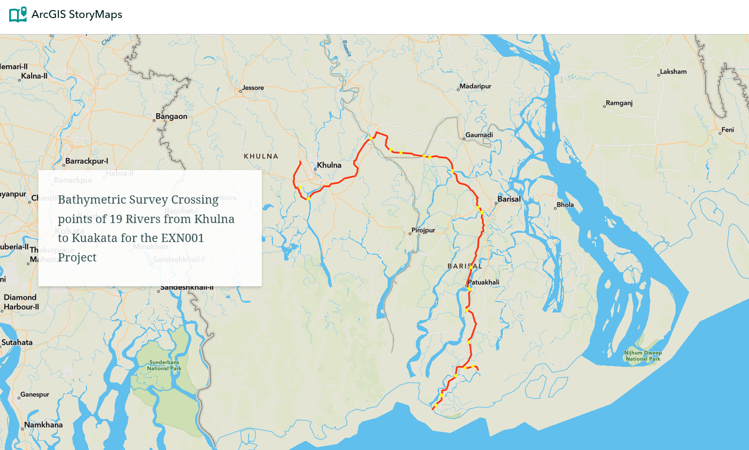
River Crossings Tour:Khulna to Kuakata Pipeline Route

Interactive ArcGIS StoryMap mapping all 19 river crossing points along the Khulna-to-Kuakata pipeline route (Project EXN001), built from bathymetric survey data I oversaw in the field. Combines a drone video of waterbody and agricultural features along the Khulna segment with a mapped tour from the Solmari River (start) to the Khaprabhanga River (end), giving stakeholders a real, navigable view of the terrain instead of a static report.

ArcGIS StoryMaps · Bathymetric Survey · Drone Video

View on ArcGIS StoryMap ↗

APR 2022

GEE Remote Sensing Indices

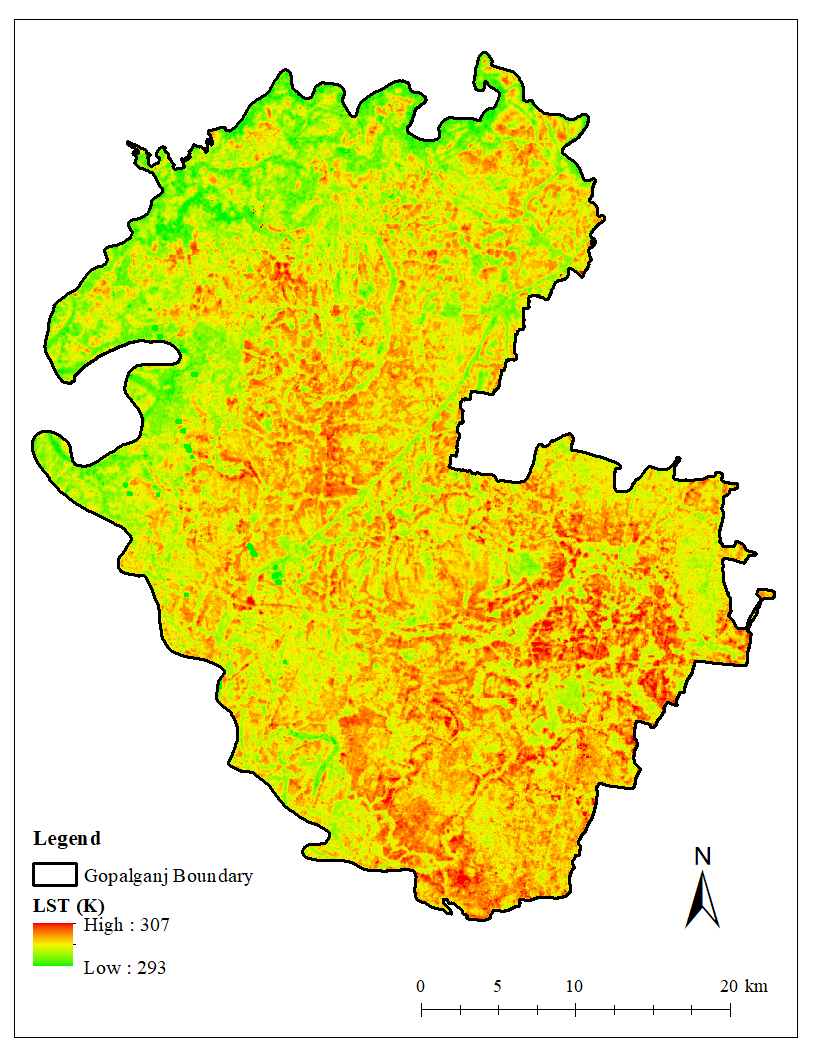
Remote sensing index computation and visualization using Google Earth Engine, including spectral indices for land cover and environmental analysis for identifying a suitable location for green infrastructures in the region. For stormwater runoff analysis, the SCS-CN method was employed, with key measures such as Land Use Land Cover (LULC), Land Surface Temperature (LST), Normalized Difference Built-up Index (NDBI), and Normalized Difference Water Index (NDWI) determined using Google Earth Engine. Additional considerations include the Urban Heat Island Effect, park proximity, stormwater runoff, and image analysis, which will be integrated into a Multi-Criteria Suitability Analysis to comprehensively evaluate the area's environmental and urban planning needs through green infrastructure.

Google Earth Engine · Spectral Indices

View on GitHub ↗

AUG 2022

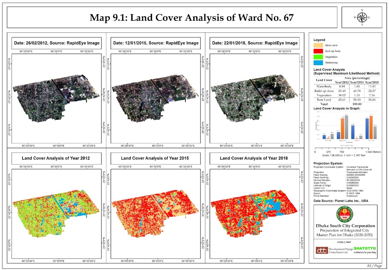
Integrated City Master Plan-Dhaka (2020–2050)

Funded by Dhaka South City Corporation. Performed large-scale geospatial, raster, and network analysis across 70 urban wards, including LULC change detection and 2050 land-use prediction via spatiotemporal modeling, and authored a GIS-based traffic management plan analyzing road networks and route optimization.

ArcGIS Pro · LULC Change Detection · Spatiotemporal Modeling

Experience

Timeline

  1. Sep 2025 — Present

    Graduate Teaching Assistant

    University of Denver, Dept. of Geography and the Environment

    Support instruction in GIS workflows, spatial data analysis, and computer cartography; lead weekly lab sessions (~25 students) in ArcGIS Pro and ArcPy; evaluate student assignments and communicate complex spatial analysis concepts through written and verbal instruction.

  2. Sep 2025 — June 2027 (expected)

    MS in Geographic Information Science

    University of Denver, Dept. of Geography and the Environment

    Capstone: built a slope-adjusted pedestrian network model to measure 15-minute-city accessibility to groceries and transit across the Denver-Aurora-Lakewood region, then used spatial statistics (Global & Local Moran's I, Getis-Ord Gi*, GWR) to test whether that access is equitably distributed. Found that roughly 1.5 million residents lack walkable grocery access, concentrated in outer suburbs, while access clusters around the urban core.

    Coursework: Geospatial Artificial Intelligence, Advanced Python Programming in GIS, Geographic Information Analysis.
    GPA: 3.95/4.00

  3. Mar 2023 — Aug 2025

    Research Consultant-Energy & Infrastructure Geospatial Analytics

    Center for Environmental and Geographic Information Services (CEGIS), Dhaka, Bangladesh

    Built end-to-end geospatial data pipelines integrating multispectral satellite imagery, UAV data, and vector datasets for infrastructure feasibility and environmental impact assessments. Conducted automated LULC classification from high-resolution imagery; produced analytical maps and spatial datasets for government stakeholders.

  4. Apr 2022

    Bachelor of Urban and Regional Planning

    Khulna University of Engineering & Technology (KUET)

    Thesis: identified suitable locations for green infrastructure using a Multi-Criteria Suitability Analysis, combining stormwater runoff modeling (SCS-CN method) with Google Earth Engine-derived indices, LULC, Land Surface Temperature, NDBI, and NDWI, alongside urban heat island effect and park proximity, to evaluate environmental and urban planning needs across the study area.

    Coursework: GIS and Remote Sensing, GIS in Urban Planning.
    GPA: 3.48/4.00

Publications

Writing &
presentations

  • Peer-reviewed journal article · 2021

    Haque, M. N., Alam, I., & Rahman, A. A. (2021). Assessment of Ecosystem Services and Disservices in Urban Environment Using Multispectral Image Analysis and Geospatial Mapping. MIST International Journal of Science and Technology, 9(1), 55–65. [DOI]

    Led the core geospatial analysis: tracked ecosystem service and disservice change across two Khulna City Corporation wards over 15 years (2005–2020) using NDVI and NDBI multispectral indices, DEM, and service area analysis to map rising built-up area and vegetation cover against worsening drainage and waste management.

  • Peer-reviewed journal article · 2020

    Nitu, S. F. F., Rahman, A. A., & Haque, M. N. (2020). COVID-19 Scenario and Possible Crisis Management Plan in Bangladesh: A Review. Journal of Engineering Science, 11(2), 45–60. [DOI]

    Led the core data analysis behind a 10-sector crisis response framework (education, economy, government, medical services, and more), evaluating Bangladesh's pandemic-era policy response and proposing a post-COVID coordination structure for future crises.

Contact